Underwater Domain Awareness (UDA) Framework for Sediment Management
Sediment management refers to the holistic management of sediment supply from rivers to coast taking into account the full range of human activities as well as sediment trapping by dams. Siltation and soil erosion is a natural process required to maintain a balance between source and sink. However, interference from anthropogenic activities causes disbalance in the process leading to significant increase in siltation rate. Water reservoirs, inland navigation systems, harbour basins, fisheries and ground water sources are the most effected from accumulating sediments. Suspended sediment affects light penetration and degree to which it is blocked is known as turbidity. With increasing turbidity, visibility or clarity decreases due to scattering of sunlight by the suspended particles making it difficult for visual feeding animals and suppressing the growth of algae and macrophytes. Rapid siltation also increases soil salinity and sediment deposits are known to cover the spawning sites of fish which interferes with their life cycle. In inland waterways, sediment deposits, in form of deltas, causes channel logging. Many rivers change their course due to sedimentation making them difficult to navigate. In water reservoirs storage loss is a major issue. In India, 0.95% of gross reservoir storage is lost annually to sediment deposition. Additionally, blockage of tunnels and spillways as well as damage of turbines and equipment from erosion are other problems faced by reservoirs due to siltation. Harbour basins also regularly deal with coastal erosion. A common practice for siltation management in coastal regions is marine dredging. However, lack of dumping sites and expensive equipment pose limitations and need to be tackled professionally. With 5,202 large dams and many more small dams and barrages, 111 Inland National Waterways worth 20,275 kms spread across 24 states and a total coastline length of 7516.6 km, India’s involvement in hydro projects is huge and the above mentioned problems scale up significantly causing enormous costs to the national economy. Therefore, it is critical to develop a framework for sediment management arises which could be employed before every water based project.
Data Collection & Analysis:
Understanding the sediment structure of an area is important before deploying any measures to deal with the problem. The first step is collection of data pertaining to bathymetry, sediment type, seabed morphology and geochemistry. This can be done through in-situ data sampling during field surveys, aerial photography and ROV Surveys. However unfavourable topographic conditions and land cover often make conduction of complete field surveys difficult. In such scenarios, Digital Elevation Model (DEM) analysis could be used which provides 3D visualization of earth’s terrain generated from remotely sensed data that is collected by satellites, planes or drones. Satellite remote sensing provides a quick method for monitoring sedimentation in lakes/reservoirs however it fails to provide very precise information which could be deployed for effective desiltation processes. Acoustic methods like echo signal analysis, seabed acoustic imaging and sonar are upcoming alternatives for sediment mapping due to their ability of providing information in detail and better management of fluctuations.

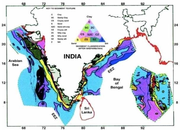
The Exclusive Economic Zone (EEZ) of India is divided into three: West coast, East coast and the Andaman region; demarcated by sedimentological characteristics. Since the major rivers draining into the eastern coast provide huge terrigenous input, it is highly rich in sediment whereas western coast has sparse sediment deposits. The Andaman region is covered with volcanic ridges having very thin sediment deposits. India has shown a positive progress in terms of bathymetric measurements through marine surveys in EEZ. The Geological Survey of India (GSI) did 19,81,478 km2 of seabed Mapping out of 20,14,500 km2 in EEZ from 1983 to 2014 through over 700 cruises. Operation strategy included marine surveys at closer intervals & systematic ocean bottom probing.
The data collected from various sources needs to be converted into a uniform standard through the process of Harmonization. Further processing with GIS provides new openings for more quantitative use of geomorphological mapping.
The Challenges:
The random behaviour and substantial diurnal as well as seasonal fluctuations of tropical littoral waters present a lot of challenges during data collection, analysis, framework formulation and implementation. This has led to a lack of understanding of underwater medium and gaps in data coverage.
Sub-Optimal Sonar Performance:
Sonar is a potential tool for bed sediment classification as it is inexpensive, easy to use, light weight and have lower power demands providing opportunities for use in a wide range of rivers. However, the efficiency of sonar sensors is reduced in the shallow tropical waters due to proximity to the boundaries which causes multiple interferences & reflections of the traversing acoustic signal resulting in its modification. This does not happen in deep sea waters since interactions of signal with surfaces and aquatic life are minimal there. Surface fluctuations, temperature and salinity variations also influence acoustic propagation. Composition of ocean bed is also essential to be known since it affects the reflection of acoustic waves. For example, sandy bottom will absorb the noise and we will not get any reflected signal. Marine life tends to live closer to the shore in warm littoral waters. Sounds created by them also adds to the background noise and degrade the signal.
Lack of Dredging Framework:
With rapid growth of global shipping fleet, there is an increasing need to expand the Indian ports and make deeper channels as well as berths to attract larger cargos so that greater revenue can be generated. This requires efficient dredging on a large scale. However, a number of challenges come in the way of optimizing the dredging system.
The lack of detailed soil investigations causes variations in the expected outcome and the measured results which leads us back to the requirement of proper sediment classification. The disposal of dredged materials is also a matter of concern due to a lack of dumping sites and the need for higher investment. The dredged material has a lot of potential applications from land creation & expansion, beach nourishment, use in landfills and construction and development of offshore berms and dams. Yet, currently there is no framework for assessment of dredged material in the country.
Stakeholder Involvement at Each Level:
Sediment management is a large-scale multilevel problem and requires cooperation from different stakeholders to avoid fragmented approach and formulation of impertinent policies in water & sediment deposition. Challenges in stakeholder involvement include lack of representation, different levels of knowledge, ineffective communication, and conflicting interests.
To tackle these challenges, a working-group of representatives from various stakeholder organizations needs to be formed and consulted to help prioritize sediment placement sites for each dredging centre in the region by collaboratively building a multi-criteria decision model.
The Opportunities:
Considering the large amount of geoscientific data being collected and much more to be documented in coming years, there is a need for development of a single robust marine data management system which should be user friendly, easily accessible, retrievable and easy to upgrade along with development of dedicated onshore data processing centres.
A structured framework for soil characterization, contaminant level, dumping site selection, cost analysis and treatment methodology needs to be in place before carrying out any dredging activity as well as a monitoring system to ensure that the framework is followed correctly.
Slope Stability Analysis:
Studies in Slope stability will help in identifying transfer and deposition zones, especially in mountainous regions prone to glacial landslides. It could also be a useful tool in mitigating the frequent disasters occurring in the Indian hilly areas, such as Uttrakhand, thus preventing widespread destruction and loss of resources. The different aspects of slope stability analysis include sheer strength and sheer force analysis based on steepness, strength of materials composing the slope, water content and external factors like shaking due to earthquake or proximity to highway traffic, construction or mining.

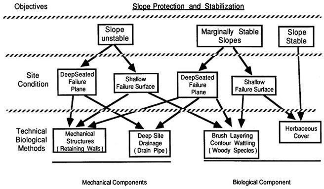
Design of slope protection and stabilization is achieved through an appropriate combination of biological (vegetational) and structural (mechanical) components such as culverts, ditches and water bars. It involves site analysis, site preparation, disruption time analysis (whether the destruction is immediate or shows long term effects), seeding and planting the suitable species.
Sediment Storage Systems:
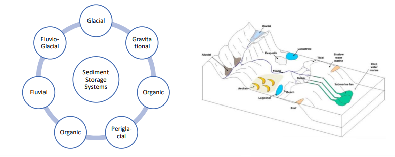
Analyzing different sediment storage systems for the Indian Subcontinent could provide some new insights to the initial development of the sediments from different sources and could help in tackle the roots of the problem. For instance, moraine dynamics show rock glacier permafrost are potential storage system of debris, however, are not studied enough because of incapability of field observation in evidencing them.

Similarly, Sedimentary Depositional environment describes the site where sediment is accumulated because of physical, biological and chemical processes as well as the associated rock types that will be formed after lithification. The Fluvial systems are deposited by rivers and streams, Lacustrine deposits are sedimentary rock formations at the bottom of ancient lakes while Aeolian deposits are transported by wind. These systems can give information about sedimentation patterns in different areas and help in predicting the exact framework for management in different geographical locations.
Sediment management has the potential to play an integral role in the sustainable development of India. Many activities are strongly interdependent on efficiency of sediment management – be it flood control, cargo transport, navigation, water supply or power generation. While sediment is a promising resource, if not handled carefully, it can become a threat to the national economy. The challenges are many, from collection of accurate sediment data to implementation at ground level with stakeholder involvement. Hence, there is a pressing need to formulate a holistic sediment management framework which will serve as a practical reference in dealing with any project concerning sedimentation.

Rishika Khanna
About Author
Rishika is currently pursuing a B.Tech (Mechanical) from Indian Institute of Technology, Delhi (IIT Delhi) and interning at Maritime Research Center, Pune for the summer of 2021. She is currently working towards formulating a proposal for Sediment Management for India under the UDA Framework.


