- Oceans are one of the most crucial components for supporting life, yet we know more about the topography of Mars than we do about the earth’s sea floor.
- Acoustic Sediment Classification aids in efficient assessment, monitoring and conservation of seafloor dynamics which includes sediment bearing pressure, benthic ecosystem and the abiotic components.
- The United Nations Convention on the Law of the Sea (UNCLOS) is the primary authority for ocean governance across the globe.
- Proper data availability and accessibility is necessary for any scientific, technological and economic developmental goals.
- Indian Ocean contains most diverse lifeforms and lies at one of the major trade cross-sections of the world still lags behind in regional co-operation and security arrangements in place.
Introduction
Our oceans cover approximately 70% of the earth’s surface and play a critical role in supporting life, from the air we breathe and the food we eat to weather and climate patterns. Moreover, Indian rivers are the richest repositories of biodiversity and can be classified as endangered species. Indian rivers hold about 50% of all aquatic water plants and are home to thousands of migratory and resident water birds, amphibians, reptiles, riparian plants, Phyto, and zooplankton species, etc. Despite their vital functions, our understanding of such water bodies remains limited. With increasing technological expertise and an ever-growing burden on the current resources, the need for exploration deep into our water bodies is pressing. Recreational, commercial, and military maritime uses demand properties of the waterbed. For locating stable environments and ensuring the proper operation of structures, pipelines, and other installations on the surface of and buried within marine sediments, construction projects on waterbeds frequently require extensive knowledge of strength, deformability, and hydraulic, thermal, acoustic, and seismic properties.
Understanding the structure of the seabed/riverbed requires a comprehensive examination of the topography and composition of surface sediments. This is based on the classification of the sediments. The Indian Ocean Area is rich in petroleum, natural gas, and vital minerals like iron, manganese, nickel, and gold.
Civilian and military establishments must conduct seafloor and sub-bottom studies to predict the seabed or riverbed’s biological, geotechnical, and acoustic properties. This information could be used across domains like seabed engineering.
Once introduced into marine habitats, sediment particles start dispersing due to the hydrodynamics, meteorology, climate, and bottom morphology. The bottom structure keeps changing with the natural processes. The sediment texture impacts several key biotic and abiotic marine environment components, and it is recognized as a critical aspect in several fields. For example, sediment particle size significantly affects the variety and composition of benthic communities, organic carbon, and pollutant dispersion. Hence, sediment texture must be examined for the topographical study, the biological characterization of benthic environments, and the environmental assessment of marine coastal areas influenced by human activities.
The scientific community in India emphasizes the need for additional research and evaluations as a basis for debates on transboundary water management in the country.
Technological efficiency
Although individual Indian projects may comply with the terms of the IWT, many analysts contend that stringing several dams on the western tributaries will have negative cumulative effects downstream. This is because the IWT does not require systematic aggregate impact evaluations. Many people in Pakistan are also concerned that when more installations are added, Delhi will be able to control river flows to a greater extent, thereby suffocating Pakistan’s economy. India responds that Pakistan’s water problems are the result of Pakistani mismanagement and that its construction projects on the western rivers are “run-of-the-river” structures, meaning they are unable to impound large amounts of water. The treaty offers outdated technical guidance that is unable to address the ongoing technical issues with Indus. There are several disagreements regarding the western rivers of the Indus. They result from the treaty’s ambiguous language and basic requirements. To prevent impediments to the course of progress, we require an updated, state-of-the-art treaty.
Conclusion
Beyond governing relations on the Indus, the treaty’s larger significance is essentially symbolic. The pact served as a reminder that the leaders of India and Pakistan might cooperate to find reasonable solutions to issues affecting their countries’ relations. The geology of the Indus Basin’s riverine region and the unforeseen political events that led to the treaty’s creation served as its foundation. Some commentators foresee a potentially violent conflict, possibly “water wars,” between India and Pakistan as the basin’s fresh water supply declines and the demand rises. The Treaty’s fragmented or divided governance runs counter to the principles of integrated water resources management (IWRM), which is promoted by hydrologists, environmentalists, and engineers who contend that basin states must respect the interdependence of various users and recognize the watershed as an ecological whole to provide riparians with a collective good. Since the treaty is a static technical document, it cannot address contemporary, complicated problems like climate change and sustainable development.
IWT’s lack of adaptation is a downside. The IWT is a permanent agreement that has no expiration date, in contrast to treaties like the 1964 Columbia River Treaty between the US and Canada, which allows either of its signatories to choose to renegotiate it after 50 years. Article XII of the IWT’s Final Provisions stipulates that “a validly ratified treaty concluded for that purpose between the two governments” must be signed for the treaty to be changed. This remains the challenge.


Maritime governance systems around the globe
Recognizing that these shared resources are the common heritage of humanity, their exploration and exploitation must be carried out for the benefit of humanity as a whole by the UN Sustainable Development Goals, concrete laws, and regulations are required to protect marine biodiversity in light of the vast potential for exploration and increasing human interventions in the oceans. Hence, several international, regional, and national frameworks have been established to restrict the overexploitation of natural assets. Modern national and multinational ocean governance is the outcome of the nation-state and international order established by the United Nations after World War II (UN). Adopted in 1982, the United Nations Convention on the Law of the Sea (UNCLOS) established a comprehensive system of law and order in the world’s oceans and seas, including regulations regulating all uses of the oceans and their resources. The extensive document has 320 articles and nine annexes. UNCLOS also controls the exercise of jurisdiction by signatory states within an exclusive economic zone of 200 nautical miles. In addition to the convention, several additional agencies have suitable frameworks for the exploration and management of the marine environment safely and securely. The International Seabed Authority (ISA) is an intergovernmental organization regulating international seabed activities, defined as the seafloor, ocean floor, and subsoil located outside of state authority. The International Union for the Conservation of Nature is also concerned with protecting marine life by emphasizing ocean governance, which includes protocols and agreements for conserving regions outside state control. The International Convention on the Prevention of Marine Pollution from Ships, or MARPOL, was established in 1973 by the International Maritime Organization as the global instrument for reducing marine pollution from ship sources.
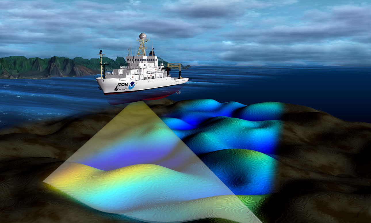
Many studies and exploration endeavours are more extensive in the North Atlantic, Mediterranean, and Eastern Indian oceans. The sophisticated economies of North America and the European Union (EU) have established well-structured technical knowledge with proper documentation of scientific data, making it easily accessible to various relevant institutions. The Environmental Protection Agency (EPA) in the United States provides information on benthic ecosystem evaluation, monitoring, and management. It includes projects that contribute to watershed-based management, the prevention of aquatic pollution, the control of ocean dumping sites, the analysis of coastal conditions, the development of productive partnerships, and the facilitation of community-led scientific activities. The National Oceanic and Atmospheric Administration (NOAA) assists decision-makers in identifying viable options. We lead the country in watching, measuring, evaluating, preserving, and managing coastal, ocean, and Great Lakes regions. The United States Geological Survey (USGS) is amongst the top agencies characterizing the geologic structure, energy, biological and mineral resources, and planetary-scale processes under the ocean floor. While the EU enacted the Marine Strategy Framework Directive (MSFD), requiring EU member states to study and monitor their marine environment to achieve good environmental status for their marine waters, including their biodiversity and seabed integrity, the EU also enacted the Marine Strategy Framework Directive.
India, too, undertakes its exploration and research in the central Indian Ocean region. India was recognized as a pioneer investor in 1982, and a site holding polymetallic nodules in the Indian Ocean was located due to India’s persistent efforts. India is among the top eight nations conducting a long-term exploration and uses the program for polymetallic nodules. Under the Ministry of Earth Sciences, the National Centre for Coastal Research (NCCR) has started monitoring marine litter’s spatial and temporal distribution throughout Indian coasts and adjacent waterways. The Automated Ocean Pollution Observation System (AOPOS) was commissioned in 2018 by the National Centre for Ocean Information Services (INCOIS) to protect India’s 7500 kilometers of coastline. AOPOS is a cutting-edge oil spill detection and tracking system built for the Indian Ocean and monitoring other types of marine pollution.
Furthermore, the Geological Survey of India conducts geological investigations and surveys across India. It provides fundamental earth science information to the government, business, and geoscientific forums worldwide. A member of the National Biodiversity Authority, established by the National Biodiversity Act of 2002, is always present in the EAC on River Valley Projects. Under the Ministry of Shipping, the Inland Waterways Authority of India (IWAI) principally performs projects for constructing and maintaining inland waterway transport infrastructure on national waterways. The Government of India’s Ministry of Environment, Forest, and Climate Change’s Botanical Survey of India (BSI) is responsible for the survey, research, and conservation of India’s plant diversity, flora, and endangered species, as well as the collection and maintenance of germplasm and gene banks of endangered patent, and vulnerable plant species.
India: A long way ahead
Yet, there is an urgent need to scale up the capability and capacity of these institutions owing to the growing demand of the nation’s ambitions to be a key player in the IOR. The lack of scientific and environmental data collection and sharing is a setback regarding socioeconomic progress and the blue economy. There are just a handful of publications on microplastic contamination in Indian rivers, even though India is a big country with thousands of waterways. In addition, the absence of a governance structure, inadequate data, and limited resources imply that few financial and technical institutions are available to address the difficulties. The Indian Ocean Region (IOR) presents several formidable obstacles. Its mild temperature makes it susceptible to climate changes like monsoons, tsunamis, cyclones, and strong winds.
Additionally, the tropical littoral seas of the IOR hinder the performance of any kind of sonar due to their suboptimal performance. In addition, the rich biodiversity of IOR’s oceans increases the need to conduct comprehensive surveys and store and distribute data properly. India’s national strategic and environmental strategy must address the need for a singleton authority to coordinate these operations throughout the marine realm.
The lack of substantial governance and database hamper our freshwater’s socio-economic growth and conservation. Sediment analysis data is essential for comprehending how sediments travel through a river system and are transferred downstream. The quality of sediments in a river system may be evaluated using such methods. For instance, sediments with a high organic composition may indicate significant pollution levels or fertilizer enrichment. They may also be used to track the evolution of sediment properties through time. This data may be used to monitor changes in river shape, sediment availability, and sediment quality. Thus, classification techniques may give vital information to help river ecosystem management choices. This information may, for instance, be used to influence choices on sediment dredging and river restoration programs.
Hence, during the study, we will analyse the existing technological and governance knowledge used by worldwide players. We will investigate the numerous worldwide research and emphasize the guidelines and data availability methods in place. Such frameworks will be examined, and a plan will be developed to facilitate the deployment of these systems not just in the Indian Ocean but also in India’s freshwater systems. One of the essential parts of the research is to comprehend the connection between the many domains of the seabed, one of which is the equipment’s synergy, which would significantly reduce the technical complexity, hence conserving resources. The planned system would pave the way for future initiatives by the Government of India, allowing it to have data easily accessible for projects of strategic and environmental significance. In the long-term, it would not only simplify the present system of governance but also lead to the capacity building and upskilling of the many stakeholders, enhancing the nation’s socioeconomic growth.
Thus, developing sediment classification and exploration operations would be a big boost for safeguarding the nation’s defence, sustaining international commerce, conducting marine animal research, and achieving sustainable development, given the expanding aspirations of the countries around the IOR.

Romit Rajendra Kaware, Department of Civil Engineering, IIT Delhi
About Author
Romit Rajendra Kaware is a final-year student pursuing B.Tech in Civil Engineering at IIT Delhi and is currently working as a research fellow at MRC. His keen interests lie in scientific research in structures and materials since it helps him increase his understanding of the processes used in constructing robust infrastructure. Moreover, Romit is passionate about contributing his knowledge of civil engineering in the maritime domain, which has the capacity to benefit the nation.


