
By: Deepak Kumar (IIT Kharagpur)
India’s maritime security is threatened by thousands of small, unregistered, and AIS-off vessels that evade traditional monitoring systems.
Conventional methods and generic AI models struggle to detect small, low-contrast boats that dominate India’s fishing fleet.
SAR imagery provides all-weather, day-night coverage, but needs specialized AI to detect small vessels effectively.
- Our SAR-specific AI solution bridges this gap by detecting suspicious ships even in AIS-dark zones using open satellite data.
- This empowers India’s maritime agencies to protect coastal security, enforce regulations, and strengthen initiatives like Maritime Domain Awareness and the Blue Economy.
What Are Dark Ships—and Why They Matter?
India’s Maritime Blind Spot: What the Numbers Say?
Here’s what the data reveals:
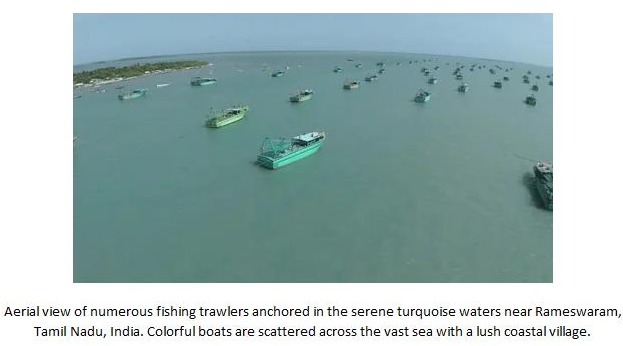
● India has over 2.5 lakh registered fishing boats (Ministry of Fisheries, 2022)
● Nearly half of India’s fishing boats still lack Automatic Identification System (AIS) or Vessel Monitoring System (VMS) devices
● This gap is especially profound among smaller, traditional vessels, which make up a significant portion of the active fleet, leaving many boats untracked.
Why Existing Solutions Fall Short?
Multiple technologies monitor India’s coastline, but each has critical blind spots—especially for small, unregistered fishing boats:
● AIS Tracking: Depends entirely on vessels choosing to broadcast their position. Easily disabled or spoofed.
● Coastal Surveillance Radars (CSRN): Effective within ~50 km of the shoreline. Not useful in deep-sea zones.
● Optical Satellites (Sentinel-2, Planet): High-resolution but ineffective during cloudy weather or at night less impactful in Indian monsoon zones.
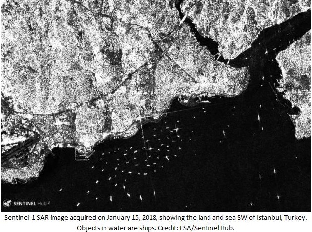
● SAR Data (Sentinel-1): Can see through clouds and at night, but raw SAR images are complex and noisy, requiring advanced preprocessing and calibration to identify ships.
● Traditional Algorithms (CFAR): Fail in coastal clutter, struggle to detect small and low-reflective vessels like fiberglass fishing boats.
● Generic Machine Learning Models: YOLO or Faster R-CNN and other structured models perform well on large ships but often struggle with small vessels due to feature loss, noisy sea backgrounds, and poor scale handling—especially in complex coastal regions. These models are fast and powerful but not tuned for the subtle signatures of small, AIS-off ships.
The SAR-based AI Solution: Making the Invisible Visible
Synthetic Aperture Radar (SAR) imagery offers a unique advantage—it captures Earth’s surface regardless of light or weather, making it ideal for maritime surveillance. But SAR images are grainy and complex, especially around coastlines. Identifying a small vessel in a noisy sea background is like “finding a needle in a foggy, choppy haystack.” This is where machine learning enters. By training a model on thousands of annotated SAR images, the system learns to identify patterns, shapes, and brightness variations associated with ship targets—even small, low-contrast ones. Our solution utilizes C-band SAR data from Sentinel-1, providing regular imagery over India’s coastal waters. We preprocess these images into 800×800 tiles, filtering noise and normalizing contrast. Then, we apply a deep learning model optimized specifically for SAR ship detection.
The model: custom-built to spot what others miss
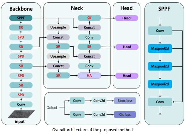
We use a customized version of YOLOv8n, a popular deep learning model for object detection. But we didn’t just apply it out of the box. Instead, we tailored the model for SAR-based maritime detection by integrating specialized modules, each playing a vital role:
● SR Module: Helps the model extract richer features from the SAR image by using multi-path filters. This increases detection clarity, even for blurred or distorted shapes.
● SPD Module: Keeps the fine-grained details that matter—especially for tiny boats under 20 meters, which most models ignore.
● Hybrid Attention Module: Acts like a radar operator’s focus—it filters out sea clutter and enhances real ship signals.
● Shape-NWD Loss Function: A mathematical formula that improves how well the model draws boxes around ships—important when the vessel is small or partially visible.
Why This Matters for India?
India faces a unique mix of challenges—long coastlines, thousands of unregistered boats, and a high risk of illegal activity at sea. Our solution offers a pathway to strengthen maritime surveillance using open satellite data, without depending solely on AIS or expensive commercial sensors. It can flag suspicious vessels in areas where AIS data is absent. It can assist Coast Guard, Navy, and marine enforcement teams in identifying priority zones.
It also contributes to India’s Maritime Domain Awareness (MDA) strategy, aligning with broader national initiatives like SAGARMALA and the Blue Economy by enhancing coastal surveillance and improving surface vessel monitoring across the Indian Ocean Region.
India’s maritime future depends on the ability to detect what others overlook. Our AI-powered system transforms blind spots into zones of clarity—empowering authorities to counter illegal activities and safeguard the blue economy. With every dark vessel detected and every anomaly flagged, we take a step toward a smarter, safer, and more sustainable Indian Ocean—where technology and vigilance work together to protect national interests and marine ecosystems.
Looking Forward
The current system works effectively on preprocessed SAR imagery and processed tiles. Moving ahead:
● Integrate AIS data to prioritize regions of interest and guide SAR image selection, enabling more targeted and efficient dark ship detection
● Build a user-friendly interface or dashboard to visualize detections and support decision-making for maritime authorities
● Explore deployment on real-time tasking platforms for operational surveillance use
● Work toward a lightweight deployment suitable for use on edge devices or coastal systems
References

Deepak Kumar
About Author
Deepak Kumar is pursuing a dual degree (B.Tech and M.Tech) in Civil Engineering from IIT Kharagpur. He is passionate about artificial intelligence, data science. He enjoys building robust, deployable systems that solve practical problems and contribute to smarter, safer environments.