Heading
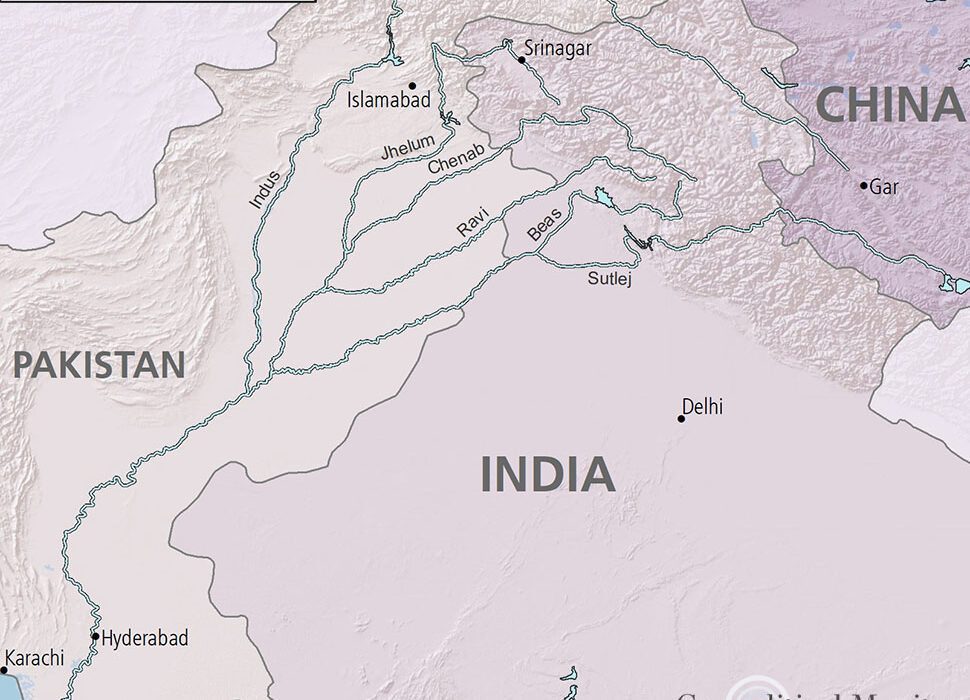
The Indus basin is shared between four riparian states – India (39%), Pakistan (47%), Afghanistan (6%) and China (8%). This river basin supported the Indus valley civilization which was one of the largest human settlements approximately from 3300 BC to 1900 BC. Since then, people occupying the basin had developed techniques and traditions to successfully farm the land, graze their animals, use the river for trade and prevent impacts of periodic flood. The history of the basin shows that it has been a coveted land where various communities have thrived amidst conflicts and collaborations.
A period that marked a changing relation between state, science and nature.
Before the interference of British, the Indus valley was managed in a generalist, qualitative fashion based on local knowledge and relationships. British initially introduced engineering principals to control and manage flood in the Sindh region. Then, in the late nineteenth century, the British started undertaking large scale irrigation projects in the Indus Basin. The outcome was the conversion of about 3-million-acre arid land into irrigated land in western Punjab. The confluence of science and politics at the time resulted in water engineering projects to control and commodify water resources. This also resulted in the emergence of Punjab ‘canal colonies’ where the farmers were intricately subjected to state’s power and plans for enhanced agricultural income. The villages were mapped thoroughly and local village communities were defined based on genealogy. But the British state conceptualized these communities in a different space from the science of engineering, thus making administration and water cooperation between local communities and engineers difficult. This period marked a changing relation between state, science and nature.
During this time, various legal instruments for water sharing between the state of Punjab and Princely states such as the Srihind canal agreement (1873) and the tri-partite agreement (1920) were present. When the time for independence and partition approached, the congress, the Muslim league, the rulers of princely states, Sikhs and other actors actively claimed parts of canal and canal irrigated land. Each with their own interests, they were now concerned about losing land and population transfers after partition. The partition grossly put most of the head works of the canal system in India which supplied water to the fields in Pakistan.
For a year under a ‘standstill agreement’, the engineers in India supplied water to the canals in Pakistan which expired in March 1948. After this, the agreement wasn’t renewed and water was shut off by India. The Indian and Pakistan representatives met a few times to arrive at a solution but they were only temporary respites such as the ‘inter dominion agreement’. Pakistan recognized that India as an upper riparian could control the Indus water to develop its own canal system which will adversely impact the already existing canals in Pakistan. Pakistan wanted to relive itself of this control.
Signing of the Indus Water Treaty (IWT): Amidst this conflict of interest, Indian Prime Minister Jawaharlal Nehru invited David E. Lilienthal for advice on water issues in India. Lilienthal was instrumental in leading seven U.S. riparian states to share Tennessee and Mississippi river basins. He was a proponent of water sharing and not water division. After analyzing the situation in India and Pakistan, he suggested joint management of the basin with financial support from the World Bank. This impressed upon World Bank the idea to act as a mediator between India and Pakistan to resolve this issue. After about ten years of back and forth of proposals and meetings, in 1960 the Indus Waters Treaty (IWT) was signed. The Treaty consists of a Preamble, twelve article and Annexure A – H.
In the upper reaches of the western rivers, India is allowed domestic, non-consumptive and agricultural uses. The development of hydroelectricity on the western rivers by India was recognized in the Treaty and thus provisions were specified. After relinquishing its claim on eastern rivers, Pakistan received funds from India, the World Bank and other donors to construct replacement canals on western rivers. The Treaty also made provision for the establishment of a Permanent Indus Commission (PIC) with two competent engineers, one from each country. The role of PIC ranged from monitoring and reporting treaty violations to conflict resolution. If the PIC fails to address the differences between the parties, the case is referred to either a neutral expert or the Court of Arbitration appointed by the World Bank.
Resolution of various hydel power projects between India-Pakistan:
Various differences, including the Salal dam issue, were resolved through PIC. In 2005, a neutral expert was requested by Pakistan for resolving the case of Baglihar Hydel Power project on Chenab River. The verdict cleared the project in favour of India but asked to make a few changes in the design. Similarly, in 2010, Pakistan opposed the construction of Kishanganga Hydel Power Project (KHEP) and requested a Court of Arbitration. Pakistan’s concern was regarding its own project on Neelam River which would be affected if KHEP was constructed. After hearing both sides, the subsequent verdict favored India’s project with minor design changes. In 2016, Pakistan again raised objections to the construction of KHEP. Other unresolved projects include the Wular Barrage/Tulbul Navigation Project and Ratle Hydel Power Project.
The Indus Waters Treaty has been regarded as a success story for preventing potential water wars between the nuclear states of India and Pakistan. Though the treaty managed to ease the tension between India and Pakistan, it excluded the interests of other two riparian states – China and Afghanistan. Also, the knowledge about climate change, environmental flows, river ecology, renewable energy, water and soil pollution, environmental stress and sustainable development are not addressed in IWT because these weren’t understood or acknowledged at the time of the IWT negotiations. For the future of millions of people dependent on the Indus Basin, these issues must be addressed through bilateral and multilateral diplomatic approach.

J Catherine
About Author
Catherine is performing her research on Indus Water River system at Maritime Research Centre, Pune.


