
By Mohd Nasar Siddiqui, IIT Kanpur
- Due to poor planning and the absence of data-driven tools like Habitat Suitability Models (HSMs), rapid coastal development, overfishing, pollution, and climate change are increasingly fragmenting habitats and endangering species like whales, dolphins, and tuna—real-world incidents underscore the urgent need for proactive, informed action.
- Habitat Suitability Models (HSMs) support Underwater Domain Awareness by guiding ship routing, identifying sensitive habitats, reducing human-wildlife conflict, and enhancing maritime safety and naval operations.
- HSMs aid in sustainable fisheries, ecotourism, and environmental impact assessments—helping align economic growth with conservation goals by informing decisions on marine resource use.
- India can spearhead regional cooperation by forming joint maritime committees, enforcing eco-sensitive shipping routes, and promoting sustainable fishing practices through awareness and real-time data integration.
Introduction
The Indian Ocean Region (IOR) is well known for its ecological diversity and strategic significance. Numerous marine species, many of which are essential to preserving the well-being of aquatic ecosystems, are supported by it. Marine life in the IOR substantially contributes to nutrient cycling, carbon sequestration, and the general resilience of ocean systems, from phytoplankton, which form the base of the food web, to apex predators like sharks and whales, which control species balance. Often called the “blue forests,” coral reefs, mangroves, and seagrass meadows provide ecosystems that protect coastlines, sustain fisheries, and regulate the climate.
However, habitat degradation, unchecked coastal development, overfishing, and the worsening effects of climate change are putting this rich biodiversity in jeopardy. The ecological and economic stability of millions of people who rely on oceans for their livelihoods is also at risk, in addition to the marine species.
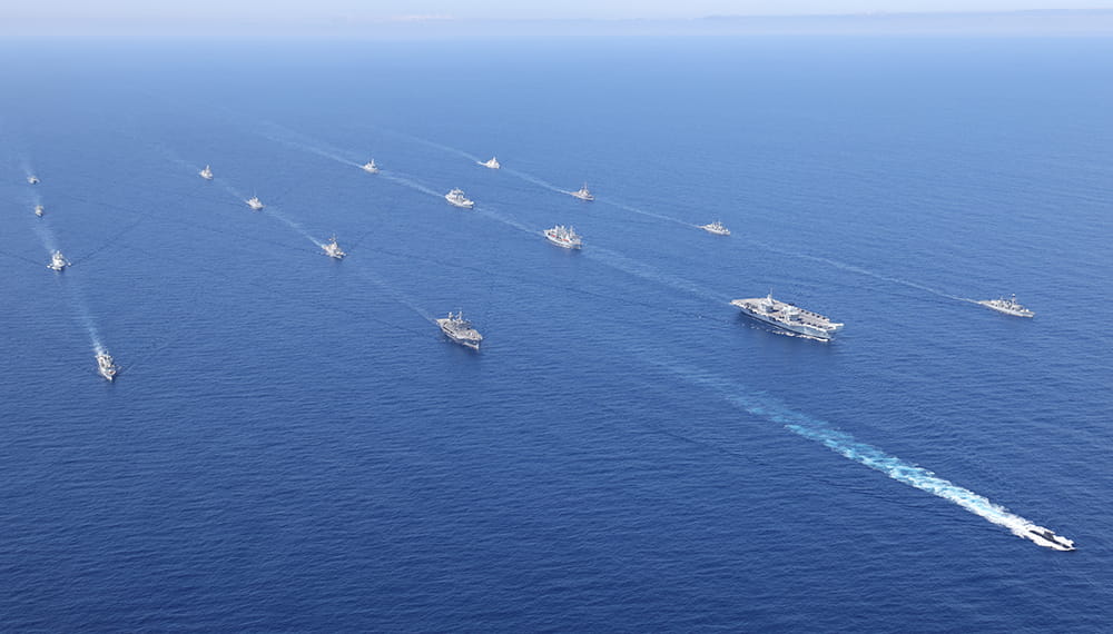
We proposed a solution, a habitat suitability model (HSM), using environmental, anthropogenic, and biotic parameters to address these urgent issues for marine species. The model supports conservation initiatives, helps identify ecologically sensitive areas, and improves Underwater Domain Awareness (UDA), which is essential for ship routing, maritime security, and sustainable infrastructure development. The Bay of Bengal, the Arabian Sea, and the nearby waters of the Indian Ocean are among the critical Indian Ocean subregions that are the subject of the study.
The IOR is a shared maritime domain with many stakeholders, including international actors, coastal nations, and regional powers. As such, it is crucial to form a global naval order. Data-driven and collaborative tools are necessary for effective ecological management in such a complicated and contested area. The AI-driven HSM can be a good solution that facilitates well-informed decision-making in security operations, conservation planning, and the growth of the blue economy. By enhancing Underwater Domain Awareness, the model supports ecological resilience and regional cooperation and also lays the foundation for supporting India’s goal of a safe, inclusive, and sustainable Indo-Pacific.
Countries such as Sri Lanka, Myanmar, Pakistan, and the Maldives are launching comprehensive regional policy frameworks. These platforms can improve coordination on everyday issues, such as the destruction of habitats by coastal development, fish stocks threatened by illegal fishing, and the substantial loss of biodiversity brought on by pollution and climate change.
In areas with high biodiversity, such as the Gulf of Mannar and Sri Lanka’s southern coast, where rich marine ecosystems are at risk, India’s leadership can be critical in creating environmentally friendly shipping routes. Implementing carefully planned shipping lanes can ensure the efficacy and safety of maritime trade while lowering risks to aquatic life.
Additionally, launching awareness campaigns for local fishermen can help promote sustainable fishing practices. These initiatives can educate people about the value of protecting marine biodiversity and the long-term advantages of sustainable harvesting. India can provide these communities with the resources they need to lessen human-wildlife conflicts and ease the strain on overfished species by combining habitat forecasts with real-time marine traffic data.
Major Incidents and Reports: Where is there a need for a Habitat Suitability Model?
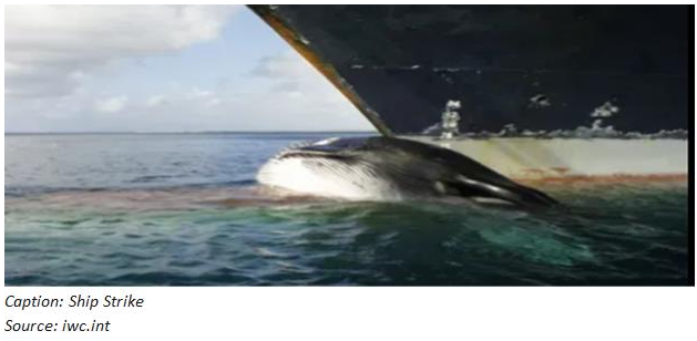
- In 2011, off the coast of Mumbai, a cargo vessel fatally struck an endangered whale shark, protected under India’s Wildlife Protection Act. Particularly in the crowded Mumbai–Gujarat shipping corridor, where endangered species regularly come into contact with dense maritime activity, the incident, which was marked by propeller injuries on the carcass, highlighted the growing conflict between marine traffic and ecological conservation.
- In 2014, vessels intruded into dolphin mating zones in the Maldives, disrupting critical breeding behaviour and causing aggressive interactions. Such disturbances threaten the reproductive success of local dolphin populations, are a significant draw for marine tourism, and underpin the country’s “dolphin-safe” tuna export industry. The potential economic loss from losing eco-certifications and reduced tourist interest could reach millions annually, jeopardising both the tourism and fisheries sectors that together contribute over half of the Maldives’ GDP
- Important blue whale habitats overlap with Sri Lanka’s southern coast, a worldwide shipping route. At least 14 large whales were killed between 2010 and 2014 alone, and numerous instances of blue whale deaths have been documented as a result of ship strikes. Since many carcasses have never been found, the number is probably higher. These collisions upset the balance of the marine ecosystem and nutrient cycling, endangering the existence of a rare, non-migratory blue whale population.
The vocalisations of marine mammals, especially fin whales, have been misinterpreted by naval sonar systems as enemy submarines or sonar signals on multiple occasions in the past. Due to their recurring patterns, these low-frequency calls have previously caused false alarms during military drills, exposing serious flaws in underwater acoustic recognition. This misunderstanding hampered naval operations and highlighted how crucial it is to differentiate between artificial and biological noises.
And many more, these incidents in the past are alarms that seek immediate attention. Neglect or poor planning causes ecological, economic, and life losses.
“These are not isolated events — they are early warnings of a larger ecological collapse unless smarter, science-backed planning is urgently adopted.”
- According to the International Whaling Commission (IWC), ship strikes are among the top threats to large whales globally, with up to 20,000 whales killed annually worldwide, a significant fraction in unmonitored regions.
- The loss of apex species like blue whales disrupts nutrient recycling (via the “whale pump”), harming productivity and the carbon sink capacity of the ocean, which directly links to climate regulation.
- Loss of “dolphin-safe” certification in tuna exports due to repeated ecological violations could risk millions in export revenues, affecting the livelihood of thousands in the island nation’s economy.
- According to UNEP, poorly planned marine activity causes $13 billion in yearly losses globally from ecosystem service degradation.
- According to WWF’s 2022 Oceans Report, 60% of marine mammals have shifted migration patterns due to anthropogenic pressures, often abandoning their traditional breeding and feeding grounds.
- If left unchecked, this habitat fragmentation causes irreversible ecological loss that could cut marine biodiversity worldwide by 15–25% by 2050.
Human operations and fragile marine ecosystems are increasingly at odds as maritime activity swells throughout the IOR. Devastating collisions between ships and magnificent marine megafauna often result from inadequate planning tools, endangering national security operations and causing major ecological disruptions. The integration of HSMs in conservation policies, strategic planning, and marine traffic management frameworks is brought to light by several real-world incidents. These models may offer priceless insights to improve maritime navigation safety and environmental stewardship.
A Fundamental Tool for Underwater Domain Awareness (UDA)
Habitat Suitability Models (HSMs) advance the objectives of the UDA framework by providing detailed, spatially explicit insights into the distribution of marine species, ecosystem health, and the interactions between human activities and the environment. Fostering the foundations of the four fundamental pillars of UDA
Security: It helps to identify ecologically sensitive areas that may overlap with shipping lanes and patrol routes, and are vital to the survival of different marine species. HSMs are essential for the Coast Guard and naval agencies. The risk of sonar-induced disruptions and potential collisions with marine mammals, such as whales and dolphins, can be reduced by identifying these areas, enabling agencies to strategically plan operations to avoid areas critical to marine biodiversity. By reducing ecological conflicts and protecting critical marine habitats, this well-informed planning improves operational efficiency, safety, and acoustic stealth in military missions.
Marine Ecology: By locating crucial habitats for threatened and endangered marine species, HSMs are essential for ecological research and conservation efforts. To preserve biodiversity and environmental balance, Marine Protected Areas (MPAs) must be designed and managed with the help of the data these models provide. HSMs promote marine populations’ long-term sustainability and recovery by zoning critical habitats away from detrimental activities. This ensures that ecosystems can flourish and continue offering vital services to wildlife and human communities.
Blue Economy: By integrating HSMs into marine resource management plans, economic endeavours like tourism, commercial fishing, and maritime transportation are more sustainable. HSMs enable efficient spatial zoning that balances economic goals with environmental stewardship by identifying ecological tolerance and resilience zones. This delicate balancing act protects marine ecosystems from overexploitation while ensuring that industries run profitably. A harmonious relationship between environmental integrity and economic growth is also promoted by HSMs, which lessens conflicts between conservation and development initiatives.
Disaster Risk Reduction: HSMs are instrumental in assessing ecological vulnerability and predicting habitat shifts resulting from climate change and anthropogenic stressors, such as pollution and habitat destruction. By mapping out these vulnerabilities, HSMs contribute to developing early warning systems and resilience planning efforts for coastal communities that rely heavily on ecosystem services for their protection and livelihoods. This proactive approach is vital in enhancing the adaptive capacity of these populations, ensuring they can withstand and recover from environmental disruptions while sustaining their socio-economic well-being.
Overall, integrating Habitat Suitability Models into marine management frameworks enhances the effectiveness of conservation efforts and promotes sustainable practices while ensuring human activities do not compromise the ecological integrity of aquatic environments.
A Tool for Conservation
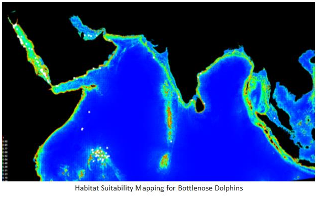
Habitat Suitability Models (HSMs) are crucial ecological tools for identifying and quantifying habitat hotspots for endangered species. They are also employed to examine the habitats and distribution patterns of these species. Both biotic (e.g., competition and predation), anthropogenic (e.g., urbanisation, pollution, and fishing), environmental (e.g., temperature, salinity, and nutrient availability), and spatial (e.g., habitat fragmentation and landscape connectivity) factors are all taken into account in these models.
HSMs are particularly instrumental in pinpointing critical habitats—such as coral reefs, which support a diverse array of marine life; dolphin migration corridors, essential for their breeding and feeding; whale breeding grounds, vital for the continuation of species; and seagrass beds, which provide critical ecological services such as carbon sequestration and nursery areas for juvenile fish. These ecological hotspots face threats from escalating human activities, including coastal development and resource extraction, making HSMs increasingly important for informed conservation efforts.
“Protecting key marine habitats today is the only way to ensure thriving oceans and livelihoods for tomorrow.”
A balance between ecology and economy
Utilised at its best, HSMs bridge the gap between ecology and economy by integrating them with the Environmental Impact Assessments (EIAs) for coastal and offshore development. Before launching projects such as port expansions, shipping lanes, oil exploration, or deep-sea mining, or before projects like port construction, ship routing, oil exploration, or deep-sea mining are initiated, HSMs can offer valuable insights into the potential impacts on marine ecosystems. Stakeholders, including policymakers, environmental planners, and conservationists, can utilise the results generated by these models to devise appropriate strategies to minimise ecological damage. The results may be used for redesigning project plans, implementing mitigation measures, or relocating proposed developments away from sensitive habitats and hotspots to preserve biodiversity and the integrity of marine ecosystems. Using HSMs, we can foster a more sustainable approach to development that balances economic growth with ecological Conservation.
By identifying biodiversity-rich areas that can be responsibly promoted for activities like whale tracking, coral diving, and dolphin watching, HSMs can direct the growth of sustainable marine ecotourism. These models assist in protecting marine life while bolstering local economies that rely on nature-based tourism by steering tourists away from ecologically vulnerable areas and toward resilient ones.
By locating high-probability habitats for target species, HSMs also have the potential to improve the sustainability and efficiency of fisheries. This enables fishermen to avoid overfished or delicate breeding grounds while reducing fuel consumption and search time. As a result, fishing supports long-term livelihoods and becomes economically and environmentally viable.
“True sustainability isn’t about choosing between profits and protection — it’s about designing systems where both thrive.”
Policy Regulation - and the importance of India's Leadership
India has a crucial strategic obligation to lead cooperative initiatives that successfully balance ecological preservation and sustainable economic growth as the maritime leader of the IOR. By launching comprehensive regional policy frameworks, India can help form joint committees with neighbouring countries like Bangladesh, Sri Lanka, Myanmar, Pakistan, and the Maldives.
These platforms can improve coordination on everyday issues, such as substantial biodiversity loss from pollution and climate change, illegal fishing practices that endanger fish stocks, and habitat disruption from coastal development.
In areas with high biodiversity, such as the Gulf of Mannar and Sri Lanka’s southern coast, where rich marine ecosystems are at risk, India’s leadership can be critical in creating environmentally friendly shipping routes. Implementing carefully planned shipping lanes can ensure the efficacy and safety of maritime trade while lowering risks to aquatic life.
Additionally, launching awareness campaigns for local fishermen can help promote sustainable fishing practices. These initiatives can educate people about the value of protecting marine biodiversity and the long-term advantages of sustainable harvesting. India can provide these communities with the resources they need to lessen human-wildlife conflicts and ease the strain on overfished species by combining habitat forecasts with real-time marine traffic data
“India stands at a crossroads — it can either react to marine crises or lead a proactive, sustainable blueprint for the entire Indo-Pacific.”

Mohd Nasar Siddiqui
About Author
Mohd Nasar Siddiqui interned at MRC in 2025 and is a B.Tech student from IIT Kanpur. He is driven by the goal of harnessing technology to solve real-world problems, where economic development and ecological responsibility can go hand in hand.